River Road Unitarian Universalist Congregation (RRUUC) dedicated our Land History wayside on October 8, 2023.
The wayside is installed along the flagstone walkway on RRUUC property and is adjacent to the sidewalk facing Whittier Boulevard. The wayside presents the results of research into the history of our land, initiated in late 2021. This research led to the creation of the Land and Labor Acknowledgement Task Force in 2022 and the decision to present the results of the research in a way that could easily communicate our land history story to our community. The research also informs the wording of our land acknowledgement plaque, which is addressed in a separate blog post.
This blog documents the thought process and sources for information on the wayside.
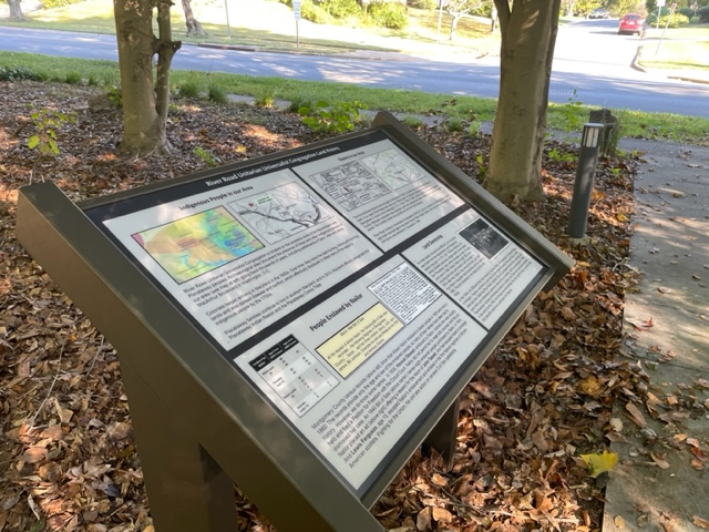
Our land history wayside addresses four related topics:
- Indigenous people in our area
- Slavery in our area, including Allison Nailor Senior, who once owned the 268 acre farm that includes the location of RRUUC today
- People enslaved by Allison Nailor Senior
- Land ownership, from the Friendship Land Grant in 1711 to RRUUC’s purchase of the land in 1961
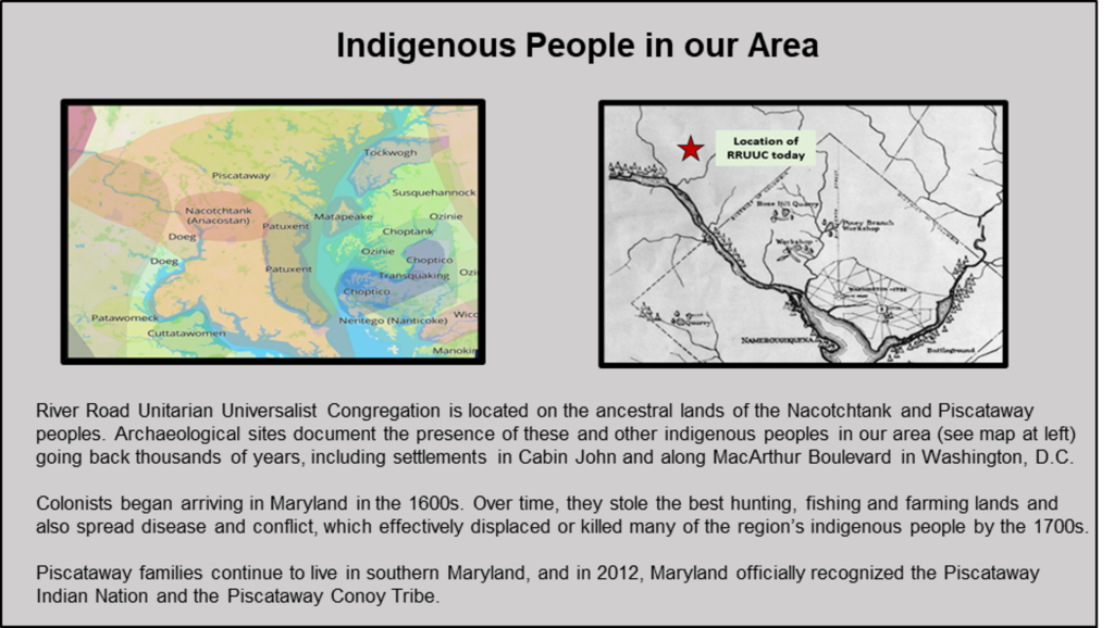
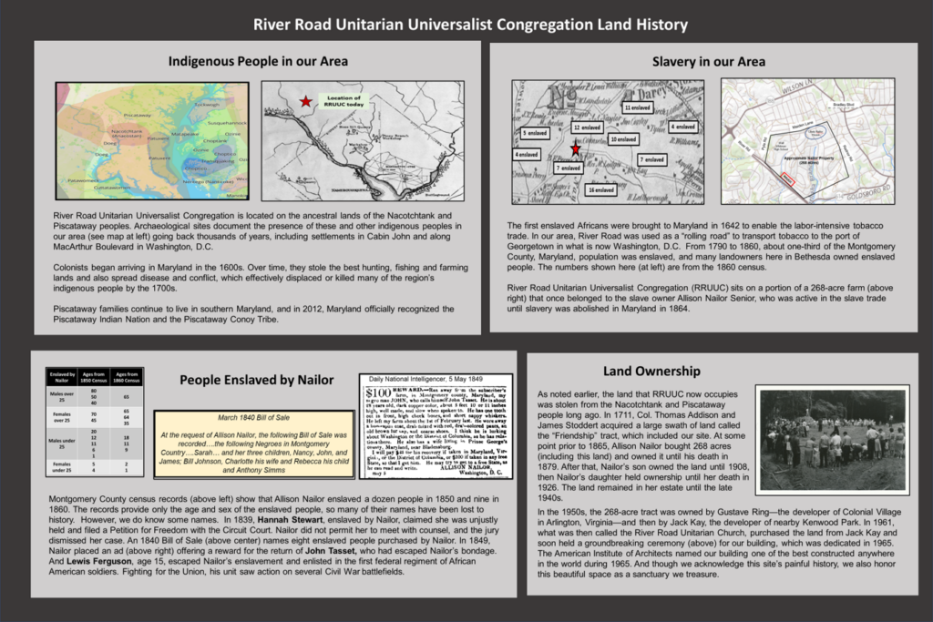
RRUUC is located on the ancestral lands of the Nacotchtank and Piscataway peoples. The map showing indigenous people’s territory is from Native Land Digital, which includes maps showing native people’s lands and a Territory Acknowledgement Guide. The map is found at: https://native-land.ca.
The map showing locations of indigenous people’s villages and workshops/quarries in our area was found in the document, “Development of the United States Capital”, prepared in 1930. The map shows many villages along the Palisades in Washington DC and in the Cabin John area. The document is found at the Library of Congress website at: https://tile.loc.gov/storage-services/public/gdcmassbookdig/developmentofuni00unse/developmentofuni00unse.pdf.
Information on the Piscataway Conoy Tribe and Piscataway Indian Nation can be found on multiple websites.
General information on native peoples in our area was found in James D. Rice’s book, Nature and History in the Potomac Country, published by Johns Hopkins in 2009. Rice is a professor of history at Tufts.
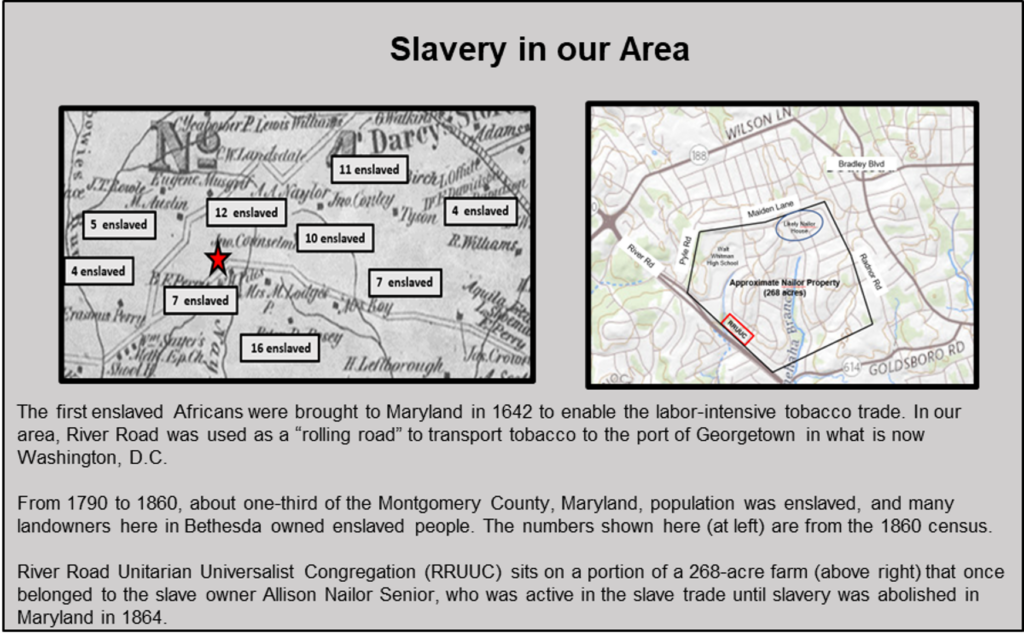
Slavery was common in Montgomery County from the middle of the 17th century though 1864. Information on specific slaveholdings was established by comparing historic land ownership, as reflected on maps with records of slave owners. The historic Bethesda area map was prepared by Martenet and Bond’s in 1865. The map can be found at the Library of Congress website at www.loc.gov. The information on the number of individuals enslaved by local landowners was found by looking up the slave owner name on the Legacy of Slavery webpage maintained by the Maryland State Archive. This webpage can be found at https://slavery2.msa.maryland.gov/pages/Search.aspx.
Allison Nailor Senior, who owned the larger tract of land where RRUUC sites, was a slave owner and trader. The location of the likely Nailor house was determined by looking at early aerial photos, which showed buildings and a clearing in this otherwise forested area. The aerial photo can be found at Montgomery County government website https://mcgov-gis.maps.arcgis.com/apps/webappviewer/index.html?id=4aa66ff533e948d89493ea3bd1e01c99.
Historian Jeff Forret’s book The Willliams Gang, published by Cambridge University Press, describes Allison Nailor’s slave transactions, including his claim to ownership of convicted slaves who were transported to the deep south. Allison Nailor Senior was named as being “conspicuous in the slave trade” by Black Freemasonry, as found at https://www.mwphgldc.com/the-early-years.
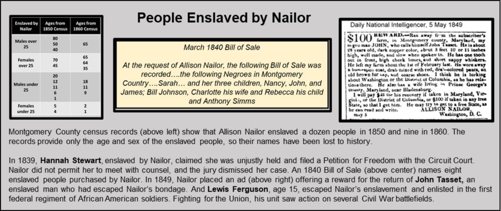
We wanted to identify as many of the people who may have been enslaved on our property as possible, but census records from 1850 and 1860 did not record the names of enslaved people, only their age, sex, and slave holder. The information on people enslaved by Nailor during the census was found at Maryland State Archives Legacy of Slavery webpages.
We searched many sources to identify as many individuals who were enslaved by Nailor as possible.
- Sarah, Nancy, John and James, along with Bill, Charlotte, and Rebecca Johnson and Anthony Sims were identified in the March 1840 Bill of Sale to Allison Nailor Senior. This was found by searching Montgomery County land transactions database, MDLANDREC.net for MSA_CE148_36 BS10, P0111. Much of this document is illegible, so there is uncertainty about the names.
- We found Hannah Stewart’s Petition for Freedom on “Oh Say Can You See”, a website that documents the challenge to slavery and the quest for freedom in early Washington, D.C. by collecting, digitizing, making accessible, and analyzing freedom suits filed between 1800 and 1862, https://earlywashingtondc.org/
- The Runaway Ad placed by Allison Nailor for Lewis Tasset was found in Maryland State Archives Legacy of Slavery website
- Lewis Ferguson’s story is documented by the National Park Service Underground Railroad project for the Mt. Pleasant Plains Cemetery. https://walterpierceparkcemeteries.files.wordpress.com/2016/01/mt-pleasant-plains-cemetery-walter-pierce-7_20_-2015.pdf
- Additional names of people enslaved by Nailor, possibly in Washington DC, are found in the emancipation petitions found at https://civilwardc.org/texts/petitions/. These petitions allowed the owners of people enslaved in Washington DC to receive compensation. Petitions name Nancy, Rachel Meekins, Caezar, William and Joseph Johnson, Sallie Butler, Martha Wharton, Lewis and Phillis.
We do not know as a fact that these individuals were enslaved by Allison Nailor at his farm on River Road, but we have multiple sources that document Allison Nailor was an enslaver and owned the property where RRUUC is currently located.
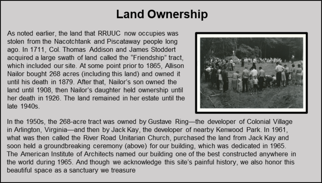
The ownership and boundaries of the Nailor property which includes the current RRUUC location was established by reviewing historic maps and land transfer records from MDLANDREC.gov. Birth and death dates for Allison Nailor Senior and his children are from https://www.findagrave.com/memorial/41347550/allison-nailor.
- The first recorded land ownership is the Friendship Land Grant to Addison and Stoddert in 1711. Boyd’s 1879 History of Montgomery County notes that the Friendship Land Grant includes Allison Nailor’s lands and nearby River Road. This history is found at https://babel.hathitrust.org/cgi/pt?id=loc.ark%3A%2F13960%2Ft2s46xv5x&view=2up&seq=6.
- We can’t confirm the date when the land was purchased by Allison Nailor Senior (1809 – 1879). It may be recorded by Land Record STS 5, page 171 in 1851, but much of that document is illegible.
- The next ownership reference, the 1904 Baist Map of Vicinity of Washinton DC shows a 267 acre tract was owned by his son, Washington Nailor (1834 – 1908). This map can be found at https://www.loc.gov/resource/g3850.la002283/?r=0.217,0.332,0.123,0.076,0.
- The Deets and Maddox 1916 Atlas shows the property was owned by Allison Nailor Heirs. The last surviving heir, as far as we can tell, was Francis Marion Nailor Clarke (1850 – 1926). This map is found at https://jscholarship.library.jhu.edu.
- The tract was purchased by Gustave Ring, developer of Colonial Village in Arlington in 1952, as recorded in Liber 1617, Folio 40 of Maryland Land Records. This deed references that the land, “Nailor Farm” was previously owned by the estate of Francis Marion Clarke, the last surviving offspring of Allison Nailor Senior.
- The tract was purchased by Jack Kay and others in 1959 as recorded in Liber 2688, Folio 221. Jack Kay was the developer of the Kenwood Park neighborhood.
- RRUUC purchased our specific four-acre property from Jack Kay in 1961 as recorded in Liber 2846, Folio 209
The RRUUC building, designed by Keyes, Lethbridge, and Condon Architects and completed in 1965 won the acclaim of the American Institute of Architects, who named our church one of the ten best buildings constructed anywhere in the world in 1966. As the jury award stated, this church is “a handsomely unpretentious building which expresses the Unitarian philosophy with clarity and vigor. In contrast with so many contemporary churches, this one does not strain for dramatic effect. Instead it achieves crisp simplicity and effortless variety, and its rapport with its wooded site is thoroughly pleasing. Viewed from any position, the relationship of forms is delightful.” See https://www.rruuc.org/wp-content/uploads/2019/03/RRUC-40th-anniv-history.pdf for a more complete history of the congregation.
The Land and Labor Acknowledgement Task Force hopes that this information is useful to reviewers and can provide the basis for future research.